McLaughlin introduces GPS-enabled utility locator
First in market to offer one-hand operation

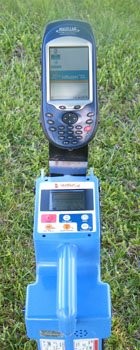
McLaughlin Group, a leading manufacturer of underground locating equipment, has introduced the industry’s first GPS-enabled utility locator that allows for one-touch operation.
McLaughlin developed software applications that allow its Verifier G2 utility locator to share real-time data with an integrated Magellan GPS unit installed on the Verifier G2 utility locator.
“The entire process is done automatically,” says Matt Manning, locating equipment product manager for McLaughlin. “Magellan GPS units are mounted to the utility locator and it’s a one-hand operation. In other words, once you’ve got the GPS unit set up, you basically are controlling all the locating and GPS recording with the push of one button on the utility receiver.”
A software application is loaded into the locating receiver. This program allows the receiver, through a serial port, to export real-time depth, current measurement index (CMI), frequency and locator mode (peak or null) to the integrated GPS unit. A second software program allows the Windows-based GPS units to receive the locator data. When the GPS unit receives that data, it cues the Magellan unit to record the latitude and longitude coordinates for the specific underground facility.
“What we’ve accomplished is an application that completely integrates and couples the GPS unit directly to the locator,” says Manning. “The McLaughlin applications allow the locator operator to push the depth button and in one step collect the depth, longitude and latitude location of that utility.”
Facility owners can download the raw data into a geographic information system (GIS) as a layer. They can use it to update existing or create new maps. It can also be overlaid on aerial photos or as-builts, along with the other surface facilities that they’ve mapped providing a bird’s-eye view of the excavation site, giving facility owners a much clearer picture of where those lines run from a big-picture perspective.
“Many times facility owner employees or subcontractors arrive at a site and see paint and flags all over, making it difficult to decipher,” says Manning. “But when they can see an aerial or birds-eye view, it becomes much clearer.”
McLaughlin
www.mightymole.com


