Since the start of the 20th century, the average global sea level has been rising at an increasing rate. As the world warms and ice caps melt, regions far from a melting ice sheet, such as Singapore, will see a rise in sea level greater than the global average. The sea level around the island today is 14 centimetres above pre-1970 levels, said the Meteorological Service Singapore (MSS) in its annual climate assessment report.
The authorities of Singapore continuously need to deal with this existential threat of rising sea levels and considering a range of solutions including reclamation and building sea walls to protect its people, economy and infrastructure from the rising tides.
Here comes into the picture Halex Construction Pte. Ltd., a marine civil engineering firm, providing innovative and cutting-edge solutions to customers in shore protection and civil engineering projects in Singapore.
The company was contracted for coastal land reclamation to create new land for further development and protect the shores of the main island against rising sea levels.
In the past years, Halex has demonstrated the ability to complete some of the most challenging marine construction projects successfully. To maintain its role as a significant contractor in shore protection and civil engineering, Halex decided to invest in digital solutions to increase productivity, profits and utilize their workforce more efficiently.
"Leveraging on technology is the best when it brings us ahead of competitors and make us competitive," said Hayden Ang, director at Halex Construction Pte. Halex believes in upgrading the skills of its crew and deploying the most advanced plant, equipment, technology and workflow procedures available in the industry in order to provide customers with the highest service standards.
When Halex was looking for applications that help to streamline work processes and increase accuracy and production levels, they decided to invest in Leica Geosystems' advanced 3D machine control solution. Besides the convenience of choosing one complete solution that fits all heavy machines and environment, Halex wanted to work with a partner, not just investing in the technology.
"Local support is the key factor in selecting such technology," said Ang. "Our entire crew was involved in the whole process, giving ideas and feedback actively to the support team at Leica Geosystems. Above training our operators to use the technology, enabling us to do our own modifications for hardware protection and providing on-field support, we had insightful discussions with Leica Geosystems experts on how to improve our workflows. This is a true partnership."
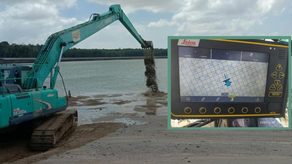
After the local Leica Geosystems team deployed the advanced 3D machine control technology on the machines and trained the Halex crew, the company was able to streamline their workflows. By introducing the Leica machine control solution with dual GNSS, no more manual stakeout is required. Besides, now Halex can provide real-time visibility and as-built verification to their stakeholders.
The technology allows the company to perform underwater excavation, filling on barges and from land with the aid of RTK GPS. The iXE3 machine control solution enabled the team to control the design levels and existing elevations using the 3D platform with profile cross-section and plan view
"No more double work and even inexperienced operators are able to guide the excavators and work more efficiently," said Ang. "Due to the low tolerance on levels and stringent inspections using multibeam surveys in marine works, it is a challenge to dredge close to the design level. Hence, with the aid of technology, with the increased machine efficiency and actual profiling of the slope, it helps us to achieve materials cost savings and reduced the time utilised to achieve our desired slope levels. Moreover, we rely less on manual supervision by experienced foremen," explains the director.
Furthermore, when filling up the rock formation, operators now can put the bucket right on the rock to check the current level without checking the tidal level, thus saving time and increase safety on the jobsite. In the past, the operators would require to check the tidal level regularly and compare with the markings on the excavator boom to get the estimated level.
"This manual checking to derive the level is both laborious and contains a certain level of inaccuracy. But now, we can get the level right at the first time," says Ang. "It transforms our excavators into highly efficient underwater tools by easily improving our efficiency by 10-20% daily."
Halex also invested in digitalization to keep their competitive advantage by increasing the accuracy and proficiency of their dredging and backfilling works. But it was also a long term investment to keep up with the shift towards a more digital and smart construction era.
"Halex believes in sharing good practices so that the whole industry can improve together. Hence we gladly recommend the machine control solution from Leica Geosystems. Not only our company benefits from digitalisation, but overall the clients' schedule and profitability," said Ang.
Company info
5051 Peachtree Corners Circle #250
Norcross, GA
US, 30092
Website:
leica-geosystems.com/en-us/products/machine-control-systems


